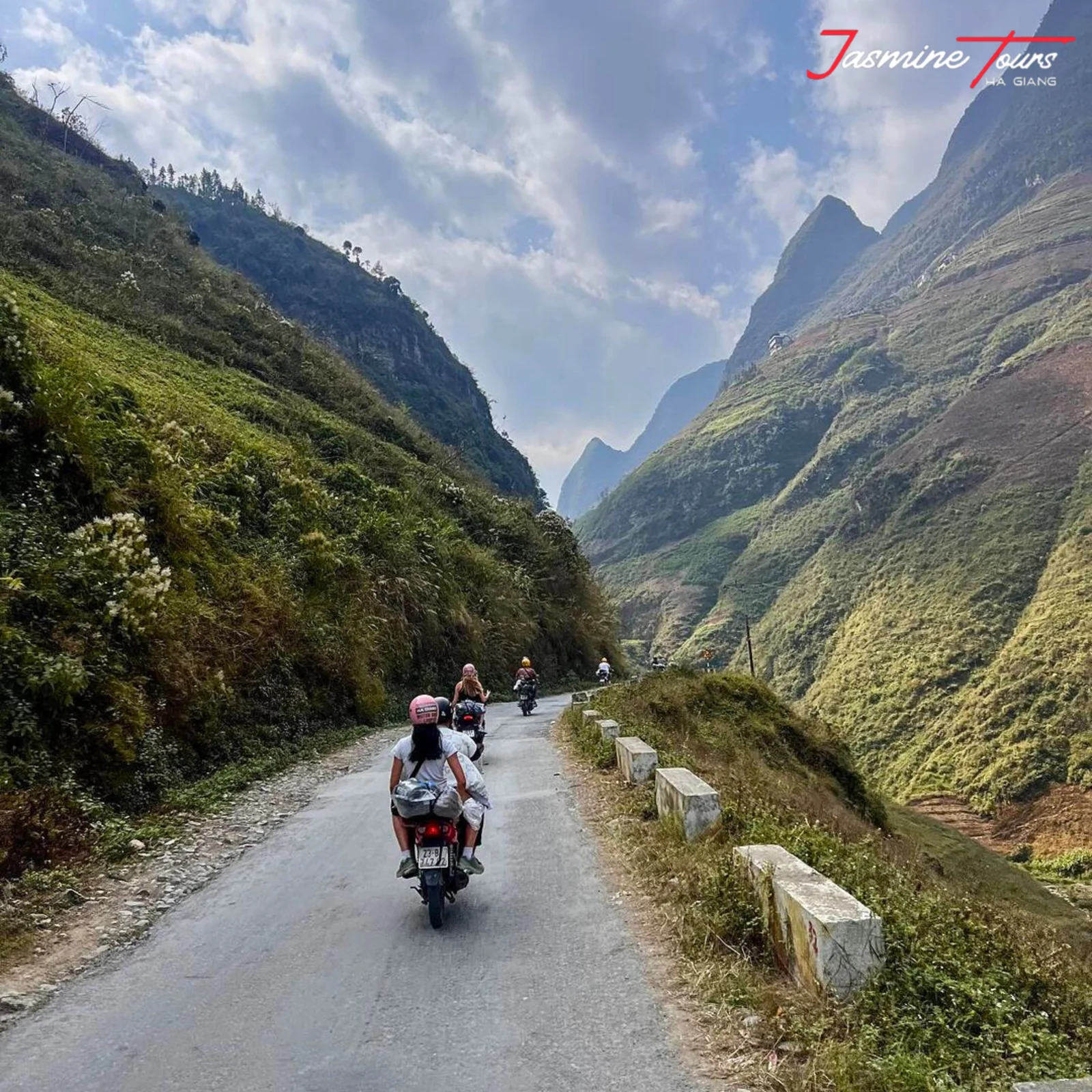
The road out of Cán Tỷ splits, and almost nobody notices. One way climbs the pass. The other drops down and follows the river. Your phone will tell you to take the river road.
From 2017 I was up here every day for three years, working out where a rider could stop, which village reliably had petrol, and which stretch quietly breaks a two-day plan in half. The three-day loop most people ride now — I drew the first version of it, on paper, for backpackers who turned up in Hà Giang with no map at all.
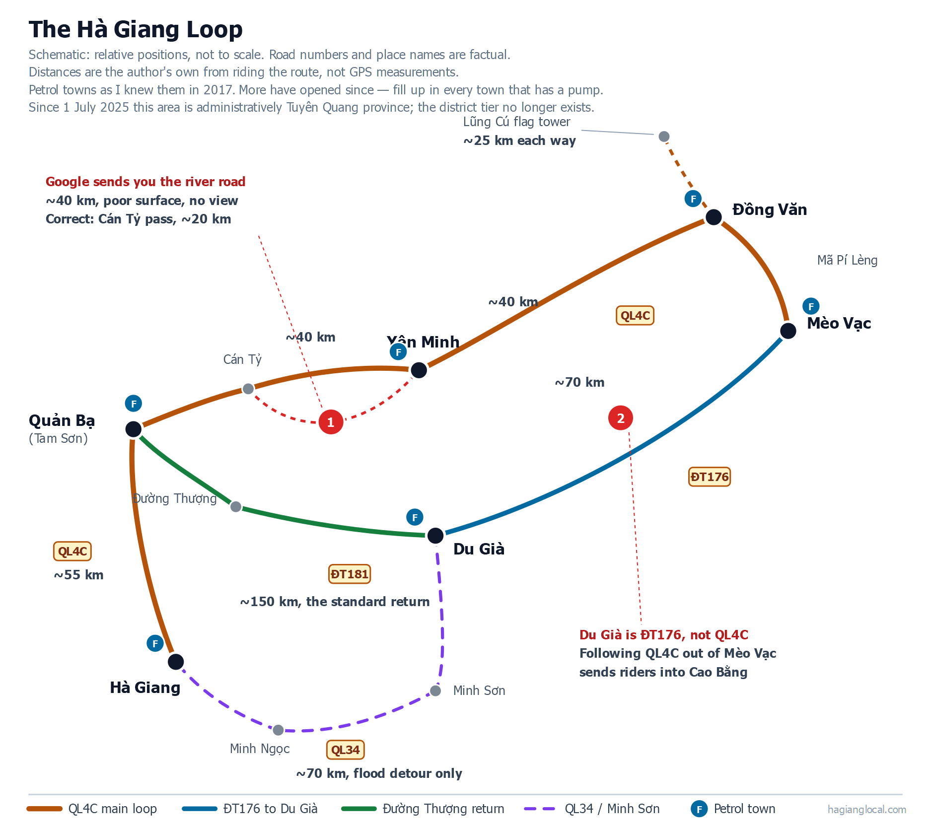
So this isn’t a description of the route. This is a Ha Giang Loop map with the things left on it that navigation apps strip out: the fuel gaps, the two places the map lies to you, and why the overnight stops sit exactly where they sit.
One question before you read on, because it changes what matters to you. Are you riding this yourself, or sitting behind someone who already knows the road?
If you’re on the back, skip to the day splits. If you’ve got the throttle, the two traps below are the reason this page exists.
The short version
- Where it starts and ends: Hà Giang city, both ends. It’s a loop.
- How long: about 450 km all in — the bare circuit, the Lũng Cú spur, and the side trips almost everyone takes. You will see around 350 km quoted elsewhere. That is the bare circuit only. It is not what you actually ride.
- How many days: three or four. Two is possible and hard. Five is a waste of your money, and I explain why below.
- The one rule that matters most: fill your tank completely in every town that has a petrol station. Not half. Full.
- The two navigation traps: the Cán Tỷ turn before Yên Minh, and the road into Du Già.
- The paperwork this map does not show: foreign travellers need a border area permit for much of the ground this route crosses — 260.000₫, about US$10. Read the note under the next heading before you set off.
Where does the Ha Giang Loop start and end?
First, a permit this map does not show — and you want it before you set off, not at a checkpoint.
Foreign travellers need a border area permit to be in much of the ground this route crosses. It costs 260.000₫ (about US$10) — my figure, August 2026. Travellers are being checked for it and fined without it; that is what I see here, not something the decrees state.
It is not a new rule, whatever you have read. Vietnam has required it since 15 June 2014 under Nghị định 34/2014/NĐ-CP. In its current wording, a foreign national entering the land border area — except in designated tourist, service and economic zones — must hold a permit from the provincial police, issued either where they are staying in Vietnam or by the border province they are entering. The current text is Nghị định 299/2025/NĐ-CP, signed and in force on 17 November 2025, which redefines the border area as the communes and wards whose administrative boundary touches the national land border and lists them in an appendix. What changed during 2026 is enforcement, not the law.
Who buys it: if you ride with a tour company, the company buys and registers it for you — our own trips and their prices are here. If you travel independently, you buy it yourself — and note the decree allows the police where you are staying in Vietnam to issue it, not only the border province. This has nothing to do with whether you drive or sit behind a driver — it is about whether you booked through an operator.
Where the zone starts is the part that catches people. By my own reckoning you are inside it around Minh Tân, roughly 21 km out of Hà Giang city on QL4C — long before Đồng Văn, and long before most riders imagine any border. Đồng Văn and Lũng Cú are inside it too. And it is entering the area that requires the permit, not staying the night there.
Added 4 August 2026. The decree references are the Vietnamese legal texts; the fee, who arranges it, and where the zone begins are from my own work here. I am not a lawyer — if you are unsure, ask your operator or the immigration office in Hà Giang city before you ride.
One thing about the name before anything else. Since 1 July 2025 Hà Giang is no longer a province — it was merged into Tuyên Quang, and the district tier was abolished nationwide at the same time (Resolution 60-NQ/TW, 12 April 2025, accessed 2 August 2026). So you will see this area labelled Tuyên Quang on newer maps, signs and official pages, and “Quản Bạ district” no longer exists as an administrative unit.
The roads, the towns and the ride are unchanged. Most guides have not caught up yet.
It starts and ends in Hà Giang city. There’s no other sensible start point, because that is where the bikes, the licences, the luggage storage and the night bus from Hà Nội all are.
From there the standard direction runs north to Quản Bạ — the town itself is called Tam Sơn, then Yên Minh, then Đồng Văn, then Mèo Vạc, then south-west to Du Già, and back to Hà Giang. You will sleep in homestays along the way — family houses that take paying guests, which is what almost all accommodation on this route is.
The loop sits in the far north of Vietnam, up against the Chinese border, and the main road through it is QL4C. Wikivoyage describes this circuit and puts the bare loop at about 350 km (accessed 2 August 2026).
Vietnam’s own tourism board routes the last day differently: out to Bảo Lâm, then back through Bắc Mê on QL34 (accessed 2 August 2026). That is a real alternative and you will see it in print.
I do not send riders that way, because it skips Du Già, and Du Già is the day most people remember.
How far is each segment?
These distances are mine, from riding the route. They are close, not surveyed.
| Segment | Distance | Notes |
|---|---|---|
| Hà Giang → Quản Bạ | ~55 km | The climb starts almost immediately |
| Quản Bạ → Yên Minh | ~40 km | Trap 1 is on this leg |
| Yên Minh → Đồng Văn | ~40 km | |
| Đồng Văn → Lũng Cú flag tower → back | ~25 km each way | Optional, and it costs you half a day |
| Đồng Văn → Mèo Vạc → Du Già | ~70 km | Mã Pí Lèng is on this leg |
| Du Già → Hà Giang | ~150 km | Three ways to do it — see below |
Day one is therefore 90–95 km. That sounds short. It isn’t, on this road.
Plan on about eight hours a day, door to door. That is riding, stops, photographs and lunch, not eight hours in the saddle.
You’re climbing almost from the moment you leave the city, and an hour of this is not an hour of highway. If someone quotes you a day that sounds much shorter than eight hours, ask what they are leaving out.
Those main segments come to roughly 405 km. I say 450 because nobody rides only the main segments — the side trips add up over four days.
I have not logged them individually, so treat 450 as my working figure, not a sum I can show you. Budget for the extra, in fuel and in daylight.
Which direction should you ride it?
North first, through Quản Bạ. Then east and south, and back along the bottom.
You can reverse it, and some people do. I don’t recommend it on a first ride.
Going the standard way, you meet the easier riding first and reach Mã Pí Lèng on day three, by which point you have two days of mountain road in your hands and the bike feels like yours. Reversed, you get the hardest and most exposed riding on the loop while you’re still learning where the brakes bite.
There is a second reason, and it is about light. Riding the standard direction puts you on the best stretches in the morning, when the cloud is still sitting in the valleys and the road is dry.
Reversed, you’ll tend to hit them in the afternoon.
Download the Ha Giang Loop map (PDF)
⬇ Download the map — PDF, A4, prints on one page
It is the map at the top of this page: the route, the petrol towns, the segment distances and both navigation traps. Print it, or save the PDF to your phone.
Download it before you leave Hà Giang. Signal in the mountains is unreliable, and the moment you most need a map is usually the moment you don’t have a bar.
Every rental shop in town will also hand you a paper map. Take that too. A paper map doesn’t run out of battery on a pass at four in the afternoon.
Where Google Maps gets it wrong
Two places. Both cost people time, and one of them costs people their day.
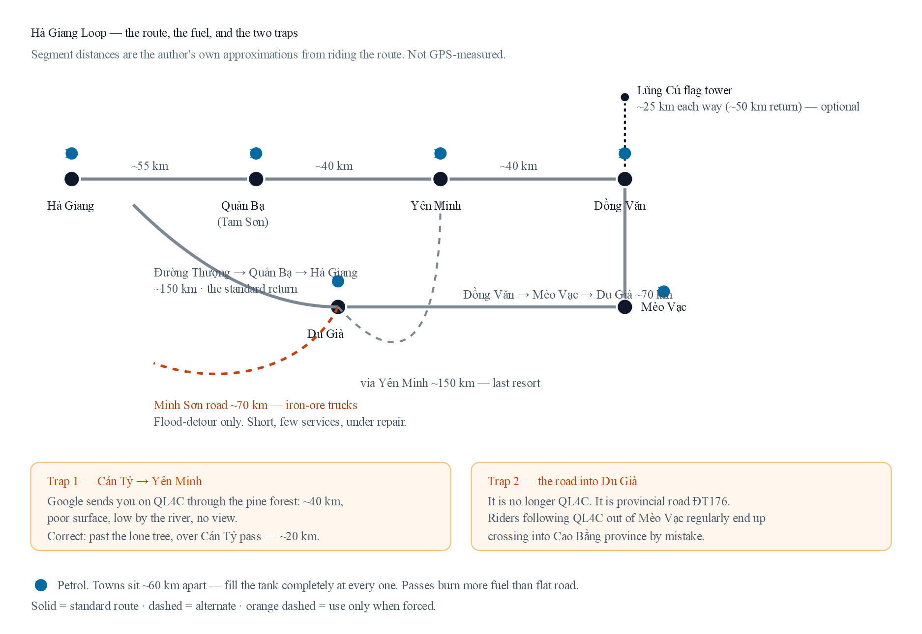
Trap 1: the Cán Tỷ turn, before Yên Minh
Coming out of Cán Tỷ, Google routes you along QL4C through the Yên Minh pine forest. That is about 40 km.
The surface is poor, it runs low along the river, and you see almost nothing, because you’re down in the valley the whole leg.
The road you want goes past the lone tree, over the Cán Tỷ pass, and into Yên Minh in about 20 km.
Half the distance. Better surface. And it’s the view you came here for.
How to know you have the right turn. Do not take this one on faith — it’s exactly the kind of junction I warn you about further down. Three things confirm it:
- You are in Cán Tỷ commune. The turn leaves QL4C; if you are still on QL4C, you have not taken it.
- Somewhere after the turn you will pass a signpost giving two different distances to Yên Minh. Take the shorter one.
- The lone tree itself — an enormous old nghiến, wide enough that several people together cannot reach round it — stands near Lao Chải kindergarten. If you have passed the tree, you are on the right road.
If none of those appear, turn back and ask in Cán Tỷ before you commit. That costs you ten minutes. The wrong road costs you the afternoon.
I have watched riders take the 40 km version, arrive tired, and never find out what they missed. The turn is easy if you know it’s coming. That’s the entire problem. The map doesn’t tell you it exists.
Trap 2: the road into Du Già
The road into Du Già is no longer QL4C. It is provincial road ĐT176.
Riders leaving Mèo Vạc who follow QL4C on their phone regularly end up heading toward Cao Bằng province instead. That’s a different province, in the wrong direction, at the end of a day that already has 70 km and Mã Pí Lèng in it.
If you take one thing from this page: leaving Mèo Vạc for Du Già, you want ĐT176.
What do you do when your phone is the problem?
Three things, and none of them is complicated.
Download offline maps before you leave. Cover the whole northern region, not just the towns. Offline maps hold the main roads accurately, which is all you need for the circuit.
They’re less good at pinpointing an individual homestay, so save your booking’s location separately while you still have signal.
Do not take the shortcut. Both Google and offline apps will occasionally offer you a shorter line that is not a road. Some of those are footpaths. Some are farm tracks that stop at a field.
On this terrain that isn’t an inconvenience, it is a bad afternoon. Unless somebody local has told you a small road is fine, stay on the numbered ones.
The Cán Tỷ turn above is the one exception on this route, and I am the local telling you that one is fine.
Carry the paper. It weighs nothing. When your phone’s dead, wet, or you’re standing at a junction with no signal, a paper map is the difference between a decision and a guess.
Fuel: what changed, and the rule that did not
This is the thing that worried me most in the early years.
When I was first working this route out in 2017, the entire loop had petrol in six places: Hà Giang, Tam Sơn, Yên Minh, Đồng Văn, Mèo Vạc and Du Già. That was it.
Six, across the whole circuit. You planned your day around them, or you pushed a bike home.
Fuel is easier now than it was. More places have opened since.
But I do not keep a current list, and I am not going to put one in front of you that your fuel planning depends on — plan on the rule below, not on my memory of which towns had a pump.
What has not changed is the geography. Most towns on this loop sit 40 to 70 km apart, and the return leg from Du Già is far longer than any of them.
Skip a fill-up and you are relying on the next pump being open, on a road with no assistance coming.
One stretch deserves naming. The standard return runs about 150 km in total, and Quản Bạ sits roughly 55 km from Hà Giang — which leaves about 95 km from Du Già to Quản Bạ with no town on my list in between.
Every other leg on this route is 40 to 70 km. That one is not.
Leave Du Già with a full tank, every time. There may be a pump on Đường Thượng now. I don’t know of one, and leaving Du Già full means it doesn’t matter.
So the rule I gave riders when there were six stations is the same rule I give today:
See a petrol station in a town? Fill the tank completely. Every time.
Not when you are low. Not when you think you can make it.
Every town, every time. Not because the tank cannot physically reach the next town, but because a pump can be closed, a climb burns more than you planned for, and nobody is coming to help you.
Half a tank on flat road is not half a tank up here. Climbing burns noticeably more fuel than riding on the level, and this route is almost entirely climbing or descending.
The number on your gauge means less than you think it does.
Where is it safe to stop for photos?
I cannot give you a list of names, and I want to be straight about why. The good stopping places up here do not have names. This is high mountain country. There is no signposted network of official viewpoints with car parks.
There’s a road, and every so often the shoulder widens enough to hold a bike.
So instead of a list you cannot use, here is the judgement I use, which works anywhere on the loop.
Stop where the road is wide, not where the view is best. On Mã Pí Lèng, where the road runs high above the Nho Quế river, those two things are often a few hundred metres apart. Almost everybody takes the view.
They stop on the outside of a bend, half in the lane, because that is where the drop opens up. Anything coming the other way meets them with no warning at all.
Three rules that cost you nothing:
- Never stop on the outside of a blind bend. If you can’t see far enough up the road to be seen, neither can the truck coming down it.
- Get the bike fully off the tarmac. Both wheels. If only half of it fits, that isn’t a stopping place.
- Park first, then look. Walk the twenty metres back to the view. Take the photograph standing on your feet, not sitting on the saddle in a live lane.
If you follow those three, you will stop maybe two hundred metres from the perfect frame, quite often. Take the two hundred metres.
The views on this route are not going anywhere. Riders who stop badly on them sometimes are.
How many days do you need — two, three or four?
Three days is the answer for most people, and four is the better trip if you can spare the day. Two is possible and leaves you no room for weather. Five is worse than four, and I explain why below.
I set these splits. Here is the reasoning, so you can argue with it if your ride is different.
| 2 days | 3 days | 4 days | |
|---|---|---|---|
| Where you sleep | Đồng Văn or Mèo Vạc | Yên Minh, Mèo Vạc | Yên Minh, Mèo Vạc, Du Già |
| Riding per day | Long | Full but fair | Comfortable |
| Time off the bike | Almost none | Enough | Generous |
| Room for rain | None | A little | Yes |
| Last day | Hard | Very long | Even |
| Cost | Lowest | Balanced | Higher |
| Who it suits | Short on time, confident rider | Most people | Anyone who can spare the day |
Five days is not in that table on purpose. I explain why below.
Three criteria decide where an overnight stop goes:
- The stop must have a homestay with real services. Not just a roof: food, water, somewhere to dry your things when it rains.
- The stops must divide the days evenly — the hours, not the kilometres. A day that runs long ruins the day after it as well.
- A longer trip must be a better trip, and a shorter trip must be harder work. If four days is not noticeably better than three, there is no honest reason to sell it to you.
Two days — one night, in Đồng Văn or Mèo Vạc
Possible. It’s a long, tiring ride with very little standing still. Take it only if you’re short on time and confident on the bike, and go in understanding that you’ll see the road more than you see the place.
The one night is a real choice, and the two options are not the same trip:
- Đồng Văn gives you the shorter, easier first day. You arrive with something left.
- Mèo Vạc puts you next to Hmong villages that have kept far more of their own life. Đồng Văn is a town, and its homestays have been built up hard — comfortable, and it feels built. The trade is a harder first day.
On this route the kilometres and the hours are not the same thing. A slow 70 km over Mã Pí Lèng is a longer day than 150 km of valley road home, so judge a split by its hours, not its distances.
Three days — Yên Minh, then Mèo Vạc
The common choice, and a good one. The days are full without being punishing, and you get the whole circuit including Mã Pí Lèng.
But be honest with yourself about the last day. On three days, the ride home is very long — that’s the price of the split, and it’s the single clearest reason four days beats three.
You finish the trip tired, on the longest leg, when you would rather be looking around.
Four days — Yên Minh, Mèo Vạc, then Du Già
The most comfortable version, and the one I would ride myself.
No day is overloaded, and the last day stops being the punishment it is on the three-day version. Day three is deliberately short: Mã Pí Lèng and Du Già are where you want the time, not the kilometres.
You get more time off the bike, more time in the villages, and enough slack that rain on one afternoon doesn’t wreck the plan.
This is the split I built the itinerary around, and the reasoning is the criteria above, applied in order.
Why not five
Five days sounds like more. It’s worse.
Each day gets so short that you are barely riding. The stops start repeating. And once you are past riding, watching daily life and seeing brocade being woven, there is not enough else up here to fill the extra day with.
There is a second reason for the ceiling at four: past that, the cost rises far enough that you are paying meaningfully more for a day that adds little. I would rather tell you that than sell you the fifth day.
Which way back from Du Già?
This is the part nobody writes about, and it’s the decision that most affects how your last day feels. There are three ways, and only one of them is the answer most of the time.
| Route | Distance | Road | When I use it | Help if something goes wrong | |
|---|---|---|---|---|---|
| 1 | Back via Yên Minh | ~150 km | QL4C | Only when both the others are out | Reachable, but you repeat the road |
| 2 | Minh Sơn → QL34 | ~70 km | QL34 | 4-day trip only, when Đường Thượng floods and you won’t repeat Yên Minh | Hard |
| 3 | Đường Thượng → Quản Bạ | ~150 km | ĐT181 | The standard, almost always | Reachable |
Option 1: back through Yên Minh, about 150 km. Same distance as the standard return, and that is the point — you pay the same 150 km but spend most of it on road you have already ridden. It’s long and it eats the day.
I only send people this way when Đường Thượng is flooded and Minh Sơn has slipped. It is a last resort, not a route.
Option 2: the Minh Sơn road, about 70 km. This drops south to Minh Sơn and joins QL34 near Minh Ngọc.
I use it in one situation, and all three parts have to be true: it is a four-day trip, Đường Thượng is flooded, and the rider does not want the long repeated ride back through Yên Minh. Outside that, no.
Shorter, and that’s exactly the problem: few services, little scenery, and the road is under repair. It also carries heavy iron-ore truck traffic.
I have watched those trucks run this road hard, and it is the reason I do not send riders down it when there is another option.
I have no accident figures for it and I am not going to invent any. I use it only when Đường Thượng floods and the rider will not take the Yên Minh route.
Option 3: Đường Thượng, then Quản Bạ, then Hà Giang, about 150 km. This runs on ĐT181. It is the standard, and it is the one I built into the itinerary. Four reasons:
- It is long enough that the trip finishes properly instead of ending at lunchtime, which is what makes people feel they paid for a day they did not get.
- There are places to eat and rest along it.
- By that point nobody is in a hurry for the ride to end, and this road gives them the time.
- If a bike breaks or someone comes off, help can reach you. On the Minh Sơn road that is much harder.
That fourth reason is the real one. The other three are why people enjoy it. The fourth is why I chose it.
When the map changes: landslides and road works
No map of this route stays correct for long, including mine.
Đường Thượng floods. When it does, the standard return from Du Già is gone and you fall back to Minh Sơn, or in a bad season all the way round via Yên Minh.
Minh Sơn slips, and as of August 2026 it is under repair besides. Check that before you count on it — repairs finish, and this page will lag reality.
Both can be true at once. That is exactly the situation where the long way round through Yên Minh stops being a bad option and becomes the only one you have.
Ask locally on the morning of the day you ride it. Your homestay knows the road before any app does, because somebody they know drove it yesterday.
FAQ
Where does the Ha Giang Loop start and end?
Hà Giang city, both ends. It is a loop.
How long is the Ha Giang Loop?
About 450 km all in, including the Lũng Cú flag tower. Most sources say around 350 km, which is the bare circuit without the side trips almost everyone actually takes.
How many days do you need for the Ha Giang Loop?
Three for most people. Four if you can spare the day — it is the version where no day is overloaded and the ride home stops being the punishment it is on three. Two is possible for a confident rider who is short on time, and it leaves you no room for weather. The full comparison, including where you sleep on each version, is in the table above.
Is 3 days enough for the Ha Giang Loop?
Yes, and it is what most riders choose. You get the whole circuit including Mã Pí Lèng. The one thing to go in knowing is that the last day on a three-day split is very long — that is the price of the split, and it is the clearest single reason four days beats three.
How long would it take to walk the Ha Giang Loop?
People do ask. Nobody does it. There is no accommodation, food or water network built for walkers on this route, and the road carries trucks. Ride it.
When should I avoid the Ha Giang Loop?
During and immediately after heavy rain, when Đường Thượng floods and slopes give way.
How risky is the Ha Giang Loop?
The risk is real, and it concentrates in specific places rather than spreading evenly: blind bends, wet descents, and roads carrying heavy truck traffic such as Minh Sơn. Knowing where those places are matters more than any general reassurance.
If you have never ridden a manual or semi-automatic bike — one you change gear on yourself, with or without a clutch — or you have never taken one down a wet mountain descent, take an easy rider — a local driver who rides the bike while you sit on the back.
If you ride at home and have already ridden in Vietnamese traffic, self-drive is fine. An easy rider costs more than renting a bike yourself.
That doesn’t make it the wrong choice — decide it on the question above, not on the price.
Can I drive the Ha Giang Loop by car?
Yes on QL4C and the main circuit, which is sealed. Đường Thượng and Minh Sơn are a different matter: I would not take a low car down either, and both can close after rain.
Do I need to download an offline map?
Yes. Signal is unreliable across most of the loop, and the places where you most need directions are usually the places with none.
Roads change up here. When Đường Thượng floods or a pass closes, I update this map. If you want the current version before you ride, leave your email and I will send it — nothing else, and nothing to buy.
Photographs on this page were taken on our own trips, and each caption carries its own date.
A note on the numbers: the segment distances, the fuel history, the two navigation errors, the return-route reasoning and the overnight-stop criteria on this page are mine, from working this route. They are honest approximations, not GPS measurements — I would rather tell you that than pretend to a precision I do not have.
Where a figure comes from somewhere else, it is linked in the text.